

We are developing various areas related to the improvement of the geological modeling tool aimed to design geological models so as to estimate the reserves, develop field projects, prepare the area for prospecting and exploratory drilling and substantiate production drilling.
Geological modelling.
Three-dimensional geological modeling is the main method to study structure features and spatial distribution of the reservoir parameters aimed to calculate the reserves, design a reservoir engineering scheme, plan a drilling scheme, estimate remaining reserves, etc.
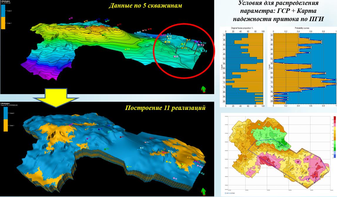
– Geological models of property distribution in the sediments of Khadumsk, Kumsk-Krestinsk, Circassian and Hot spring Suite were built (Fig.1).
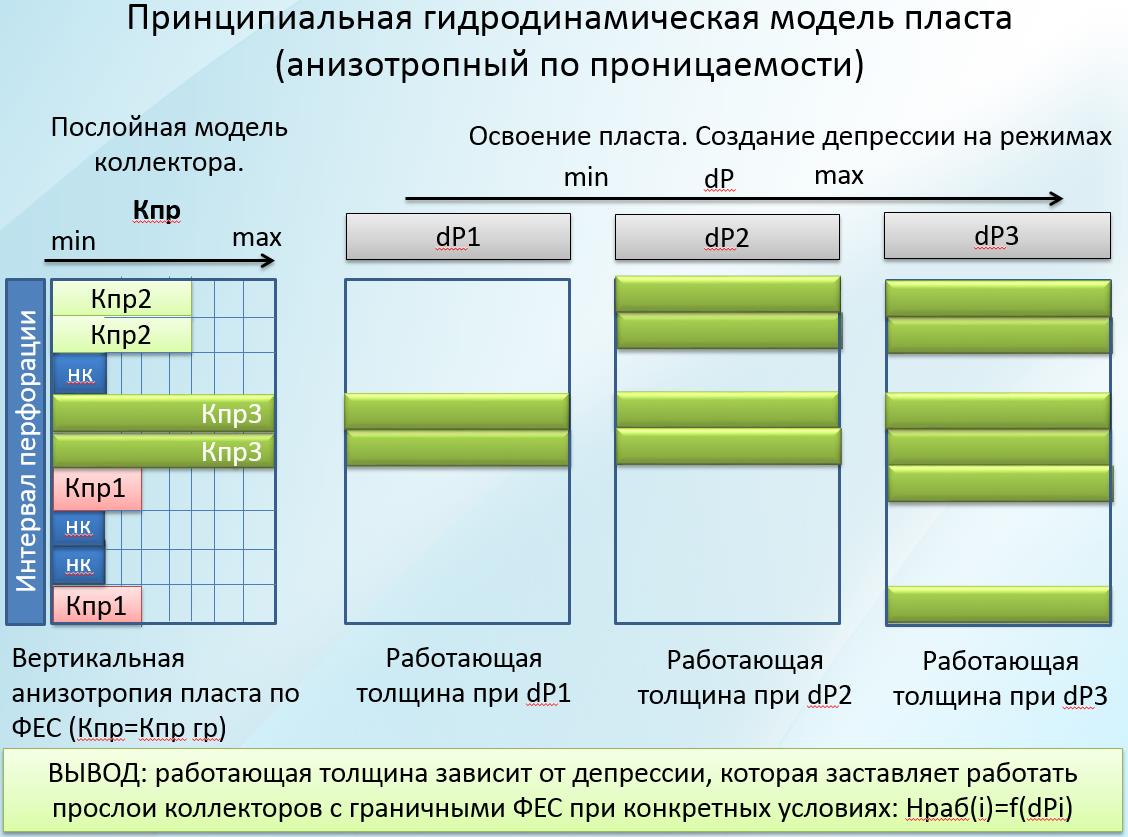
– The technique to predict the distribution of the reservoir properties heterogeneity is substantiated. Zoning of wells according to potential productivity is carried out (Fig.2).
– Structural-tectonic model of fold development is constructed and interfacing with dynamic deformation of rocks (strain- analysis, determination of the main stresses) is conducted.
Integration of geological and geophysical data
The integration of geological and geophysical data is an integral part of the exploration process and is a technology to identify prospective zones, areas and traps on the basis of data and materials of potential fields (gravity and magnetic prospecting), electrical prospecting, field geochemistry, seismic exploration and drilling. The importance and role of data integration in the search for hydrocarbon deposits and justification of prospecting and evaluation wells placement increases with the complexity of oil and gas targets’ structure. Interest in data integration as a method of optimization and increasing the efficiency of geological exploration is inversely proportional to the volume of knowledge about the structure features of the object that we are studying.
Estimation of the hydrocarbon potential and design of regional geological models plays an important role in selecting the main promising directions and objects of prospecting works. LLC “INGEOSERVICE” offers a full range of regional evaluation services using original techniques: decomposition of maps into frequency components, integration of geological data with potential fields, analysis of digital SRTM data, probability statistical analysis and many others.
The main tasks that can be solved with the integration of geological and geophysical data:
1) prediction of reflecting horizons in sections with a rare network or lack of seismic data, compilation of composite structural maps;
2) studying the geological structure of the territory, identifying and tracing zones of tectonic disturbances;
3) forecasting various environmental parameters, including areas that are promising to search for hydrocarbons;
4) determination of priority areas and areas for further exploration.
Examples:
1. A comprehensive study of an area of the Barents Sea basin of approximately 200,000 square kilometers.
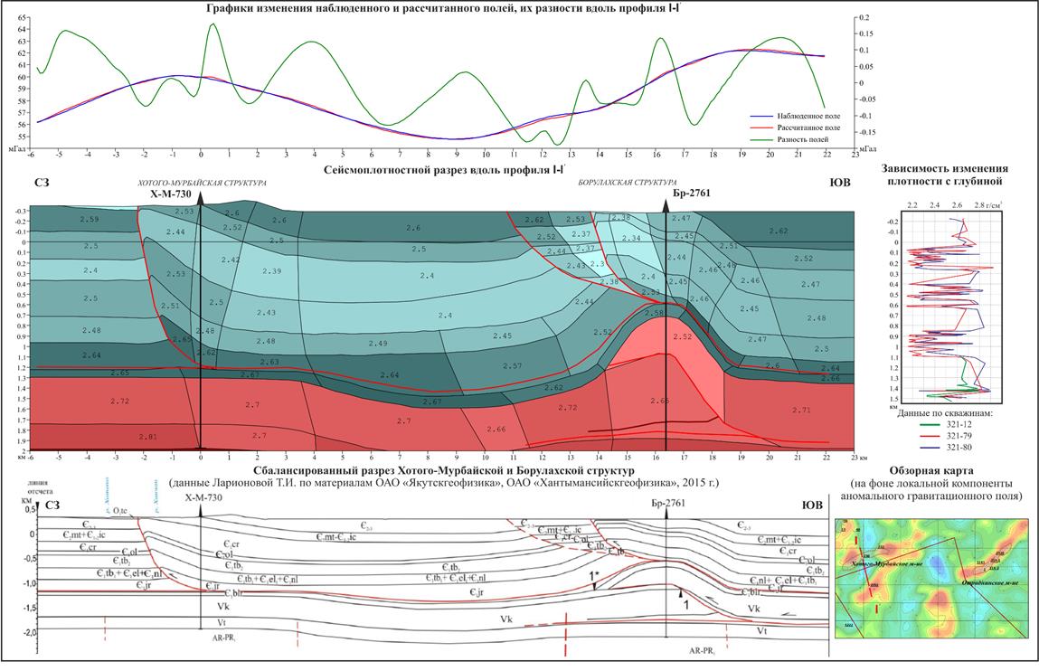
On the basis of the available software TG-2 (registration certificate №2008611947), a problem was solved – the tasks of selecting the gravitational field from the structural-density sections defined in the two-dimensional (profile) version (Fig. 3). The cross-section is approximated by a system of closed polygons with constant density. At the same time, it should be noted that it is possible to automatically determine the density in a selected set of bodies.

2. Prediction of promising hydrocarbon zones in the uppermost part of the pre-Jurassic complex (PJC) of the Urals part of the Khanty-Mansiysk Autonomous Okrug (KhMAO):
A) structural-tectonic zoning of the investigated territory on the basis of frequency analysis of fields
B) prediction of the material composition of the rocks of the uppermost part of the pre-Jurassic complex
C) non-standard zoning by a complex of features
D) evaluation of sediment prospects
3. Revision of overthrust belts through the example of Eastern Siberia.
In Eastern Siberia – within the area of Predpatomsky arch – the work was carried out on the topic “Comprehensive interpretation of well testing, core, WLS, 3D / 2D seismic data, gravimagnetic survey, electrical prospecting, geochemical surveying, space imagery data so as to clarify the geological structure, estimate the resource base.”
The modeling process consists of the selection of densities with an unchanged position of the boundaries identified through seismic data. The simulation results showed (Fig. 4) that the overthrust belts are contrastingly manifested in the gravitational field and can be indicators of prospecting for promising zones that are complicated by thrust plate systems (thrust scales, dizplicates).
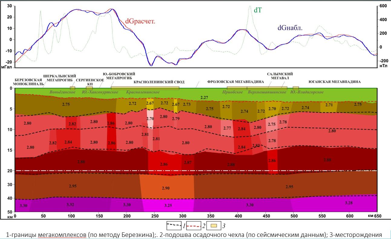
4. Restoration of structural geometry of the horizons and refinement of the deep structure of Western Siberia according to the data of potential fields (Fig. 5):
A) geological targeting structural geometry of the main horizons in the sedimentary cover in the areas with the lack of seismic data;
B) structural imaging via use of multidimensional linear regression;
C) revision of the position of the crystalline basement surface.
Geological designing
Arrangement of geological project documentation:
– programs for the whole complex of geological exploration works;
– projects of prospect evaluation survey of geological exploration;
– extension program, supplementary exploration of oil, gas and condensate fields;
– combined projects for exploration (supplementary exploration) of deposits and search for new productive structures (deposits);
– zonary projects of prospect evaluation survey of geological exploration on several oil-bearing (gas-bearing) promising structures (deposits).
Geological designing is carried out in accordance with the requirements of the “Rules of front end engineering design for geological exploration of subsurface resources and exploration of mineral deposits by types of minerals” approved by the Ministry of Natural Resources of Russia on June 14, 2016 No. 352.
LLC “INGEOSERVICE” offers a service to support geological design documentation in FSI (formerly FSFI) RosgeolExpertiza up to receiving a positive expert opinion. The staff of the company has FSI (formerly FSFI) RosgeolExpertiza experts and they have extensive experience in preparing documents in accordance with the procedure for carrying out the expert examination.
Example: for the prospective structures of the Kolpakovsky Trough (Kamchatka), an exploration program was prepared to find and develop promising gas condensate structures to maintain the required volumes of gas and condensate production at the stage of production volume drop off at the developed fields due to the search and stage-by-stage placing on production promising oil and gas condensate objects.