

The program InfoGeos is intended to render and provide interactive work with the data of electronic cartography.
It is a client-server application designed in the form of a Web page.

All the data are kept on the server GeoServer in the form of shp-files. GeoServer is an open source application to control data sources of geographic information systems (GIS) and organize the access to such data through Web Feature Service (WFS) and Web Map Service (WMS).
The program InfoGeos is located on Apache Web server. This allows you to use the program as a regular Web-site. It should not be installed on client computers, it possible just to provide the correct http-address in the URL bar as in a regular website. This service is only available within the company, however, if necessary, such information or part of it may be published for users of the global Internet.
The basis of the client part of the program InfoGeos is library OpenLayers. The OpenLayers library allows you to create a Web interface to display the cartographic materials presented in various formats and located in different WMS and WFS servers. It is a library of open-source and is written in JavaScript. In addition to rendering WMS and WFS layers into a single Web map, and also to editing the provided data (only for WFS-T servers), OpenLayers has the following features: — Adding navigation bar; — Shifting the map using the mouse. — Zooming when scrolling the middle wheel of the mouse. — Getting the coordinates of the point over which there is the mouse pointer; — Adding a panel control visibility/invisibility of map layers; —Selecting a random object and receiving the attribute information about it; — Controlling the transparency of the map layers; — Adding user-defined elements to the map (points, lines, polygons); — Many other possibilities.
The program InfoGeos is tested in Firefox and Chrome. But it may not work correctly in Internet Explorer.
Work with the program.
It is required to launch a browser and put http://www.ingeos/infogeos/. in the address bar. A page window will appear on the Web-page.

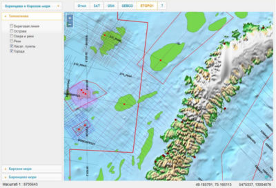
In the navigation bar there is just one active button (…). Clicking it will open a list of downloadable maps. At the moment there is just one map on the list – the Barents and Kara sea. Later this list of maps will be expanded.

When a map from the list is chosen, it will start loading the data. It takes some time, during which access to the program is blocked.

After data loading is completed, access blocking is off and you can start working with the map.

To the left, there is a list of map layers. For convenience, the layers are arranged into three folders – topographic base, the Kara sea and the Barents sea. The picture is open with the folder the Barents sea. You can see, that the map contains many different layers. The boundaries of mapping, licensed areas, Structures, Deposits, and various seismic parties. Each layer can be turned on and off using the check mark, which is next to the layer. To move the map, you need to place the mouse pointer on it, click the left mouse button and move the map in the desired direction. The map scale can be changed by scrolling the middle mouse wheel or by clicking on the buttons “+” and “ – ” located in the upper left corner of the map. However, the scale value is displayed below the list of layers.
If you change the scale of the map, the signature layers are change. For example, the figure shows that some of the seismic parties are signed, and some not. Blue seismic party in the center of the picture at the current zoom level does not have signatures, as they would be too “densely” located.

If you change the map scale, the same seismic parties get the signature. In the lower right corner of the Web-page, the coordinates of the mouse cursor appear. The first two numbers are the geographical coordinates (decimal degrees), second two numbers are the metric coordinates. To obtain information about features in the map you can just by clicking on them with the left mouse button.

The object is highlighted in blue and appears in the information window. For the window to disappear, it is necessary just to click the left mouse button anywhere on the map with no objects on.
The program allows you to connect the WMS services from third-party servers. In the navigation bar there is a row of buttons so as to connect to such services. The source data of map layers are stored on Geoserver in geographic coordinate system WGS84. Since many Web services use the Web Mercator projection, it is also called rectangular cylindrical projection Mercator on the sphere, the program projects data map layers into this projection. Buttons SAT and OSM connect MapQuest service. MapQuest is an American map service. In 2012 it was ranged as 2nd in attendance cartographic portal in the United States, trailing only to Google Maps.

Moreover, it is necessary to select off the layers of the topographic base map, otherwise they will block the information obtained from the service. The following button connects WMS GEBCO — General Bathymetric Chart of the Oceans. GEBCO operates under the joint auspices of the International hydrographic organization (IHO) and the intergovernmental Oceanographic Commission (IOC) of UNESCO.

Service ETOPO1 — global digital elevation model that includes both ground and submarine topography, with a resolution of 1 angular minute. ETOPO1 provides coverage data topographic and bathymetric measurements of the Earth’s surface from -90° to 90° latitude and -180° to 180° in longitude. Data of topographic, bathymetry integrated topo-bathymetric measurements, data measurements of the topography of the coastline and the digital data of continental relief were obtained from several state organizations of the USA, international organizations and academic institutions.

The button Off switches off the services.
Conclusion.
In conclusion, I would like to note that this is the first version of the program InfoGeos. At the moment it is limited functionally, but planned to be expanded. First of all, by transferring the load from client programs to the server, which should increase the performance, especially on lower-end computers. For easy loading, storage and sampling data, in conjunction with Geoserver, spatial database PostGIS (PostgreSQL) will probably be used. There will be additional navigation controls, such as distance measurement, search, additional features of the sample data map layers. The list of map services will also be expanded.