

LLC “INGEOSERVICE” has completed the study of Beloostrovsky licensed area on demand of LLC “Gazprom Geologorazvedka”. Thanks to coherent and professional work of LLC “INGEOSERVICE” team, the project was completed on time, in a strict time frame with complex source material, was defended and accepted by the STC of the customer.
The work was carried out in the framework of the project of field seismic surveys on Beloostrovsky, Nyarmeysky and Skuratovsky licensed areas in the Kara sea. The company was assigned the following tasks: detailed study of the geological structure of the sedimentary cover of the above mentioned licensed areas, evaluation of prospects of the Cenomanian-Albian-Aptian sediments of Marresalinskaya, Yarongskaya and Tanopchinskaya suites and deep horizons of the lower Cretaceous and Jurassic, mapping of the pre-Jurassic base, prediction of lithology and reservoir properties of the section, the construction of the seismogeological models, recommendations for placement of appraisal and exploration wells.
As a result of integrated interpretation of well data and 3D seismic data on the licensed area Beloostrovsky, the company “INGEOSERVICE” has completed the following :
– processing of seismic data using modern software and a single graph of processing with true ratios of the amplitudes with the pre-stack migration;
– seismostratigraphic binding of RW to the geological section of the wells.
– the linkage of seismic data 2D materials in adjacent areas;
– disjunctive disturbances are mapped, a tectonic model of the site is constructed;
– isochron maps and block diagrams in the reflecting horizons are obtained;
– inverse transformations are performed;
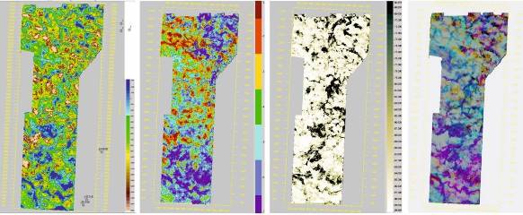
– AVO-analysis;
– the geological structure and morphology of the structures and perspective objects are clarified;
– dynamic, seismostratigraphy, paleotectonic and seismic facies analyses of the study area are performed, isopach schemes of the main sedimentary complexes are constructed;
– scheme of correlation of the wells “land-sea” is conducted;
– geological section through the recommended wells is compiled;
So as to conduct all the works mentioned above, program IngeosMAP (iMAP) (company development) has been implemented, that is used to construct digital 2D geological models
Due to the results of the work, the location of prospective traps, anomalous zones are outlined, types of hazards are identified, the maps of their distribution for each selected in the section seismic sequences are designed, their ranking is carried out according to risk, a summary map of geological hazards is compiled, calculation of reserves is performed.